|
ARABIAN (new) SARGASSO SEA
Please use our A-Z to navigate this site or return HOME
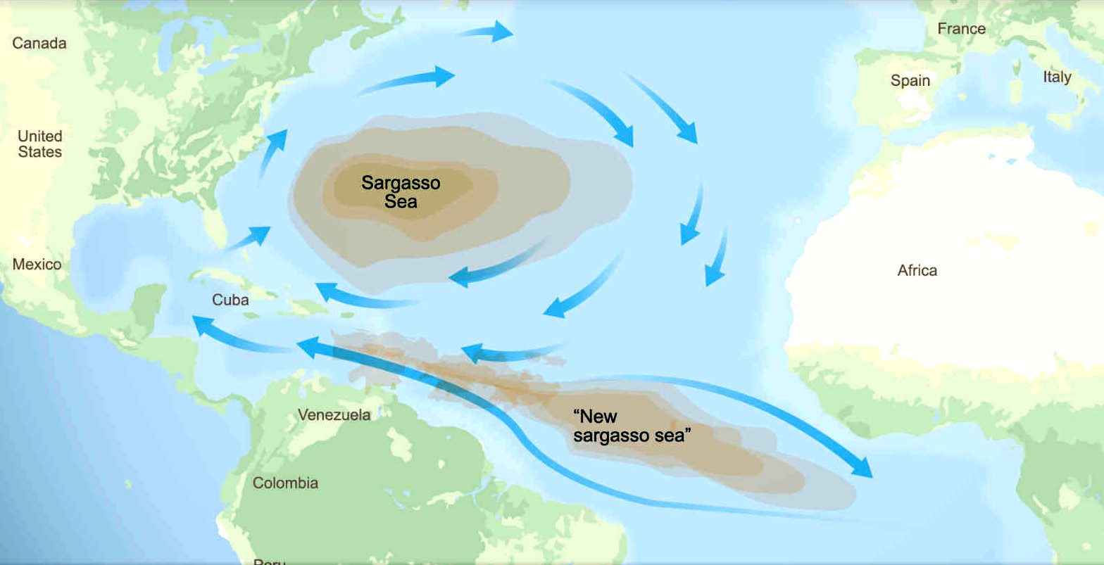
SARGASSUM - The giant brown seaweed, having shown that it can spread from North to South Atlantic oceans, could spread to the Indian and Pacific oceans as a potentially invasive species. The proof of which (as a theory) is satellite pictures, and changing wind states. The spread witnessed here, could just as easily migrate between oceans, and thence to the bays and seas within those oceans.
So, what are the chances of that happening? Could there be an Arabian Sargasso Sea, where the present welcoming waters are turned into an cesspit of foul smelling rotten seaweeds.
At this stage of the formulation of his theory, the innovator is considering the awful prospect, based on the demonstrable and devastating spread of sargassum from the North Atlantic to the Equatorial South Atlantic.
The three major oceans are all interconnected via currents and driving winds. The main barrier to migration at present, is the temperature and level of nutrients, that is lower where the seaweed mats could pass from one to another. But that is by no means a hard point, as the melting of the polar caps indicates. We are living in changeable times, where the unthinkable is taking place, as a pace faster than previously supposed.
In other words, the impossible is rapidly becoming possible. And there is no containment system at present, to prevent that from happening; no international coordination, or action plan. A recipe for disaster you may think!
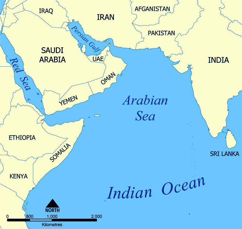
THE ARABIAN SEA
The Arabian Sea is a region of the northern Indian Ocean bounded on the north by Pakistan, Iran and the Gulf of Oman, on the west by the Gulf of Aden, Guardafui Channel and the Arabian Peninsula, on the southeast by the Laccadive Sea and the Maldives, on the southwest by Somalia, and on the east by India. Its total area is 3,862,000 km2 (1,491,000 sq mi) and its maximum depth is 4,652 meters (15,262 ft). The Gulf of Aden in the west connects the Arabian Sea to the Red Sea through the strait of Bab-el-Mandeb, and the Gulf of Oman is in the northwest, connecting it to the Persian Gulf.
The Arabian Sea's surface area is about 3,862,000 km2 (1,491,130 sq mi). The maximum width of the sea is approximately 2,400 km (1,490 mi), and its maximum depth is 4,652 metres (15,262 ft). The biggest river flowing into the sea is the Indus River.
ISLANDS
FACTUAL BACKGROUND
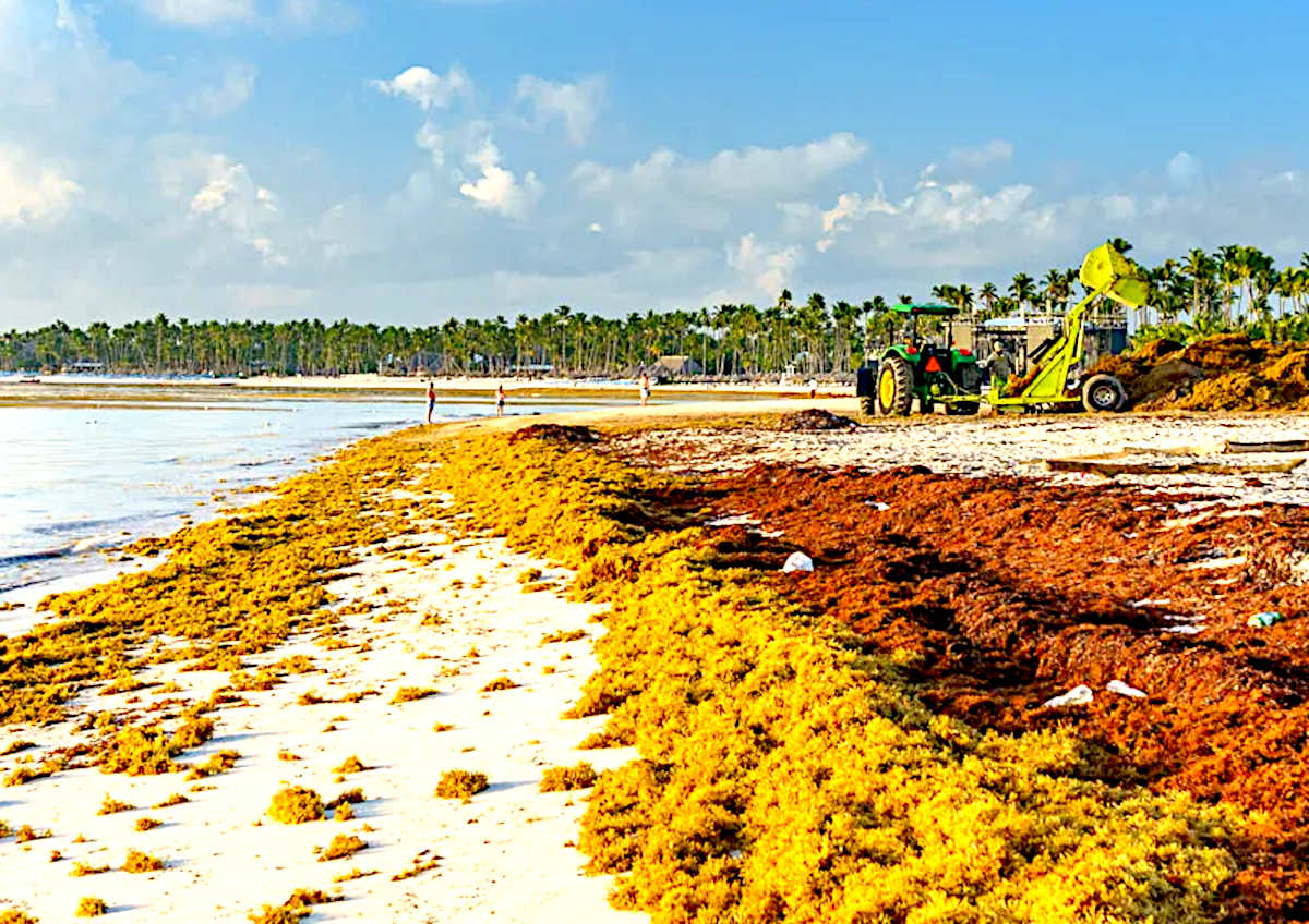
The sargassum crisis seen in the Caribbean Sea and Gulf of Mexico could be just the beginning of a worldwide plague, stemming from our inability to curb political insatiability for fossil fuels - to power failing economic strategies, based on growth, when we have already used up the planet twice over, in sustainable terms.
The answer to failed political policies is very often a jolly good war, (Russia Vs Ukraine). When all cock-ups get thrown to the wind in the media scrum, and a whitewash ensues, until the next band of post-war cutthroats is elected, each with their hands in the pockets of Lucifer's climate change deniers. That said, it would take a nuclear conflict to reduce earth's population significantly enough to brake global warming - but then the planet would be barren and unable to support human life. Hence, an unthinkable solution to all but the most desperate of homicidal kleptocrats: warmongers.
But, ignoring thermonuclear first strikes for now, even if we transition to renewables immediately, global warming will not reverse for 30-50 years at best, and that is with a fair political wind. Meaning that the conditions for sargassum to populate welcoming equatorial waters (rich in nutrients) around the globe, remains a distinct possibility. Such as the:
Atlantic - North & South Equatorial Banda Ceram Molucca & Timor Seas Pacific Ocean - North & South, Equatorial Belt (Costa Rica, Ecuador, Panama regions)
Seas and oceans in these latitudes could become inundated with macro algae, if the rafts of floating seaweed manage to navigate less hospitable barriers, such as colder regions. Which at the moment, Cape Horn and the Cape of Good Hope appear to offer some protection from invasion.
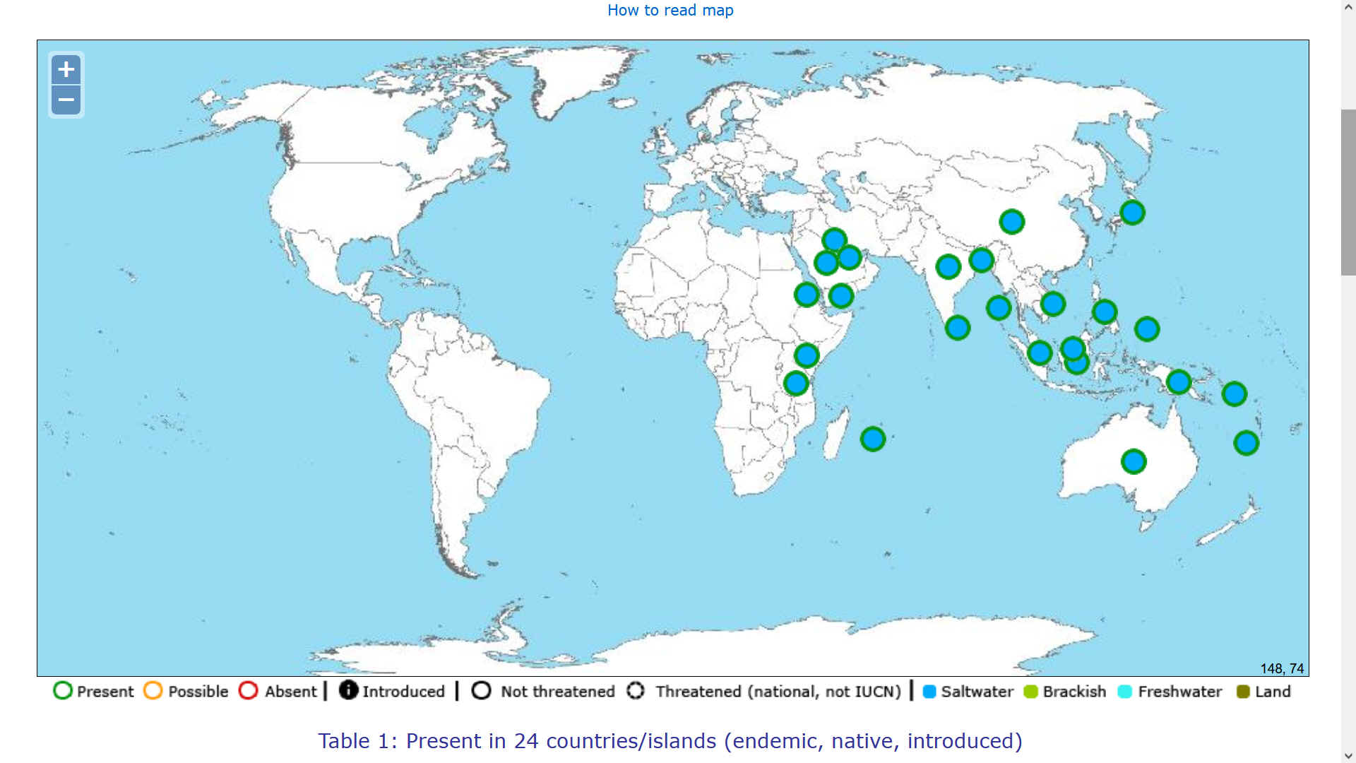
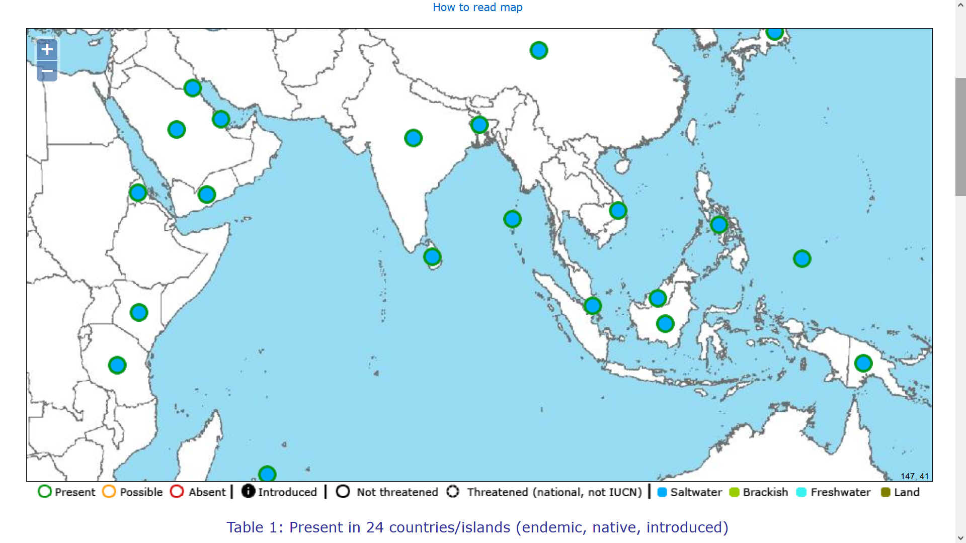
HOW TO READ THE MAP (TABLE 1) - The literature species report in a country is represented by an icon (a circle) in the middle of the country polygon.
Important: a report in the literature does not necessarily mean that the species is currently present in the country! There are errors in literature, misidentifications, and some species have been locally or globally extirpated or eradicated.
HOW
TO INTERPRET THE MAP (TABLE 1) - The icon in a country polygon indicates that the species has been reported at least once in the country, BUT NOT NECESSARILY that it is present IN THE ENTIRE COUNTRY.
This is particularly so for large countries such as Brazil, USA, Canada, Russia, China, India, Indonesia, Australia, etc.
THESIS
This is a theory being developed by Nelson Kay (as a volunteer) in 2022, based on his work with the SeaVax team from 2016 - 2020. Though mostly concerning micro and macro plastic recovery and river containment, the ocean engineering and logistical challenges posed by SeaVax are kindred concepts, and may be sympathetically adapted or even interchangeable to some degree.
Academics and scientific institutions inclined to test such thesis, or otherwise wishing to provide data or technological assistance, positive or negative, should please contact the Cleaner Ocean Foundation in the first instance. The aim being to prove or disprove the concept, to advance our knowledge in this little understood area of Oceanology/Oceanography. Degree level students are welcome and post graduates looking for their Masters or other higher level qualifications.
There are a million reasons for not doing something, and only one driver for diving into a challenge. Most people will use the manifold negatives as an excuse for sitting back in their armchairs. Every now and again, someone is foolhardy enough to roll their sleeves up - and have a go. Despite the enormity of the task.
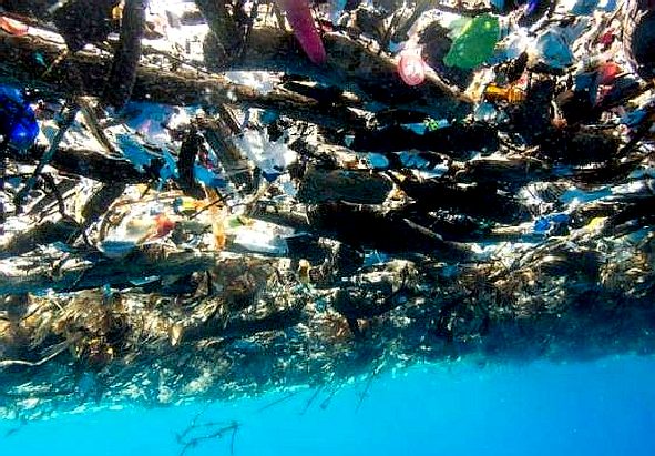
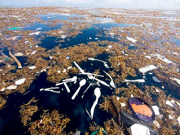
PLASTIC TIDE - These amazing pictures of a giant plastic tide were taken by Caroline Power. Please note how plastic and sargassum intertwine, creating a separation problem.
CARIBBEAN ISLANDS UNDER THREAT A-Z
Aruba (Netherlands) Cayman Islands (UK) Curaçao (Netherlands) Dominican Republic (Hispaniola) Guadeloupe
(France) Saint
Vincent and the Grenadines Turks
and Caicos Islands
LINKS & REFERENCE
https://www.openwaterpedia.com/wiki/Arabian_Sea
This website is provided on a free basis as a public information service. copyright © Cleaner Oceans Foundation Ltd (COFL) (Company No: 4674774) August 2022. Solar Studios, BN271RF, United Kingdom. COFL is a charity without share capital. The names Amphimax™ RiverVax™ and SeaVax™ are trademarks.
|