|
BAY OF BENGAL - NEW SARGASSO SEA
Please use our A-Z to navigate this site or return HOME
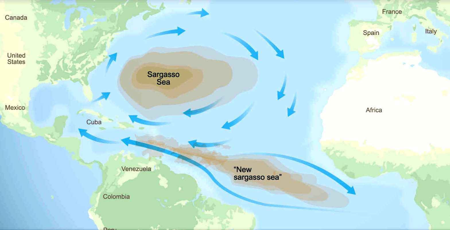
SARGASSUM - The giant brown seaweed, having shown that it can spread from North to South Atlantic oceans, could spread to the Indian and Pacific oceans as a potentially invasive species. The proof of which (as a theory) is satellite pictures, and changing wind states. The spread witnessed here, could just as easily migrate between oceans, and thence to the bays and seas within those oceans.
We are concerned that with the oceans warming at a faster rate than predicted, and with the spill over of sargassum from the Sargasso Sea in the North Atlantic, to create an Atlantic Equatorial sargassum gyre, that it is almost inevitable, and we might expect to see a South Atlantic sargassum gyre in the not too distant future, in proportion to insolation, since photosynthesis is the propagator of plant life.
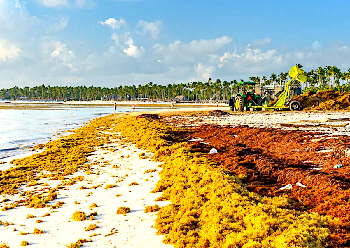
If that comes to pass, and with the Indian and Pacific oceans also warming at the same rate as the Atlantic, so generating faster currents and winds; spillage around the horns could become a distinct possibility. In which case, the Bay of Bengal would be a prime contender for a micro sargassum gyre. Dependent on location current circulation conditions. Or at least may suffer a similar fate to the Caribbean Sea, where the islands/shores therein suffer beaches strewn with mounds of sargassum, to ruin fishing, tourism and marine ecology.
ABOUT THE BAY OF BENGAL
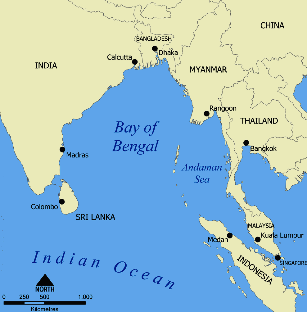
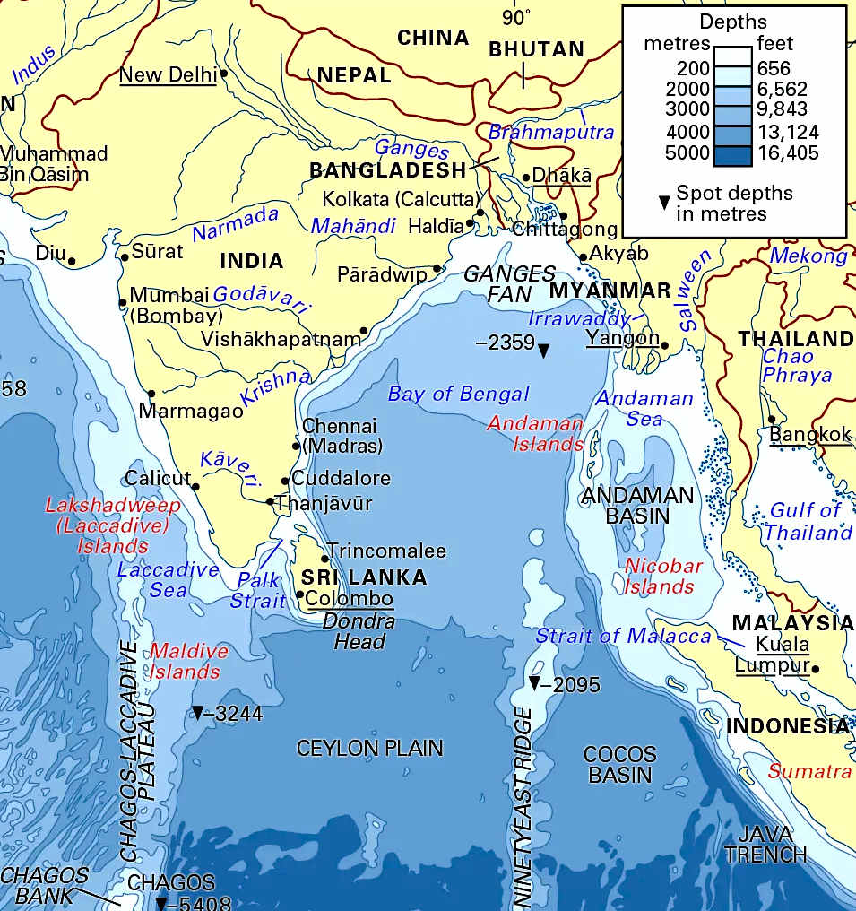
The Bay of Bengal is the northeastern part of the Indian Ocean, bounded on the west and northwest by India, on the north by Bangladesh, and on the east by Myanmar and the Andaman and Nicobar Islands of India. Its southern limit is a line between Sangaman Kanda, Sri Lanka, and the north westernmost point of Sumatra, Indonesia. It is the largest water region called a bay in the world. There are countries dependent on the Bay of Bengal in South Asia and Southeast Asia.
During the existence of British India, it was named as the Bay of Bengal after the historic Bengal region. At the time, the Port of Kolkata served as the gateway to the Crown rule in India. Cox's Bazar, the longest sea beach in the world and Sundarbans, the largest mangrove forest and the natural habitat of the Bengal tiger, are located along the bay.
The Bay of Bengal occupies an area of 2,600,000 square kilometres (1,000,000 sq mi). A number of large rivers flow into the Bay of Bengal: the Ganges–Hooghly, the Padma, the Brahmaputra–Yamuna, the Barak–Surma–Meghna, the Irrawaddy, the Godavari, the Mahanadi, the Brahmani, the Baitarani, the Krishna and the Kaveri.
Important ports include Krishnapatnam, Chennai, Ennore, Chittagong, Colombo, Kolkata-Haldia, Mongla, Paradip, Port Blair, Matarbari, Thoothukudi, Visakhapatnam and Dhamra. Among the smaller ports are Gopalpur Port, Kakinada and Payra.
ISLANDS
Bay of Bengal hogfish (Bodianus neilli) is a type of wrasse which live in turbid lagoon reefs or shallow coastal reefs. Schools of dolphins can be seen, whether they are the bottle nose dolphin (Tursiops truncatus), pantropical spotted dolphin (Stenella attenuata) or the spinner dolphin (Stenella longirostris).
Tuna and dolphins usually reside in the same waters. In shallower and warmer coastal waters the Irrawaddy dolphins (Orcaella brevirostris) can be found.
POLLUTION AND WATER QUALITY
FISHERIES OVER EXPLOITATION
Fishing overlaps national jurisdictions, both legally and illegally – overcapacity and overfishing in one location forces a migration of fishers and vessels to other locations. All countries (to a greater or lesser degree) are experiencing difficulties in implementing fisheries management, especially the ecosystem approach to fisheries. Bay of Bengal countries contribute significantly to the global problem of loss of vulnerable and endangered species. The main causes of the issues are: open access to fishing grounds; Government emphasis on increasing fish catches; inappropriate government subsidies provided to fishers; increasing fishing effort, especially from trawlers and purse seiners; high consumer demand for fish, including for seed and fishmeal for aquaculture; ineffective fisheries management; and illegal and destructive fishing.
ORIGINS
The North Atlantic Sargasso Sea is where sargassum originates and was contained for hundreds of years, until climate change and intensive farming. But should the unthinkable happen, and the invasive species take hold in the South Atlantic, from whence to spread it's biological advantage, one can imagine the dire consequences, perhaps mirroring that now ruining the Caribbean Sea. Make no mistake, the consequences of climate change and intensive, fertilizer based farming, could become a deadly world contagion, to make other epidemics seem insignificant, in terms of potential human tragedy.
An animal has a means to exhaust toxic waste, essential for a healthy lifestyle. The oceans have nowhere to dump the excrement we dump in it. They just get more polluted. Except for sargassum piling onto the shores, telling us that we have reached the limit.
So, what are the chances of it happening? Could there be a 'Bay of Bengal Sargasso Sea,' or belt, where the present welcoming waters are turned into a cesspit of foul smelling rotten seaweeds, as they release hydrogen sulphide gas to choke visitors to their shores.
COMPUTER SIMULATIONS & CONTAINMENT DEVICES
That all depends on temperature rise of seawater, combined with nutrient supply, and circulating currents, including winds. All of which is measurable, for variable algorithmic computer simulations. As has been performed on the influx to the Caribbean Sea, via the equatorial Atlantic gyre, by scientists at the University of South Florida in St. Petersburg's College of Marine Science, who used NASA satellite observations to discover and document the largest bloom of macroalgae. Others used Global Hybrid Coordinate Ocean Model surface currents (HYCOM) (Chassignet et al., 2007) and National Centers for Environmental Prediction Reanalysis (NCEP), in their simulations.
But nobody has yet created a computer model of a SeaVax Calypso or Sargasso, used in various (fleet formations) to determine if such a concept could control volume escalation, before they grow to be profusely irrepressible. Indeed such simulations may help develop such concepts in terms of capacity and operations, that they may, or may not, contain the crisis, preventing a worldwide state of emergency - by nipping it in the bud.
THEORY DEVELOPMENT
At this stage of the formulation of his theory, the innovator is considering the awful prospect, based on the demonstrable and devastating spread of sargassum from the North Atlantic to the Equatorial South Atlantic, but not yet migrating to the more general south, due presumably, to temperatures not yet being to the liking of the buoyant seaweed.
The three major oceans are all interconnected via currents and driving winds. The main barrier to migration at present, is the temperature and level of nutrients, that is lower where the seaweed mats could pass from one to another. But that is by no means a hard point, as the melting of the polar caps indicates. We are living in changeable times, where the unthinkable is taking place, as a pace faster than previously supposed.
In other words, the impossible is rapidly becoming possible. And there is no containment system at present, to prevent that from happening; no international coordination, or action plan. A recipe for disaster you may think!
FACTUAL BACKGROUND
The sargassum crisis seen in the Caribbean Sea and Gulf of Mexico could be just the beginning of a worldwide plague, stemming from our inability to curb political insatiability for fossil fuels - to power failing economic strategies, based on growth, when we have already used up the planet twice over, in sustainable terms.
The answer to failed political policies is very often a jolly good war, (Russia Vs Ukraine). When all cock-ups get thrown to the wind in the media scrum, and a whitewash ensues, until the next band of post-war cutthroats is elected, each with their hands in the pockets of Lucifer's climate change deniers. That said, it would take a nuclear conflict to reduce earth's population significantly enough to brake global warming - but then the planet would be barren and unable to support human life. Hence, an unthinkable solution to all but the most desperate of homicidal kleptocrats: warmongers.
But, ignoring thermonuclear first strikes for now, even if we transition to renewables immediately, global warming will not reverse for 30-50 years at best, and that is with a fair political wind. Meaning that the conditions for sargassum to populate welcoming equatorial waters (rich in nutrients) around the globe, remains a distinct possibility. Such as the:
Atlantic - North & South Equatorial Banda Ceram Molucca & Timor Seas Pacific Ocean - North & South, Equatorial Belt (Costa Rica, Ecuador, Panama regions)
Seas and oceans in these latitudes could become inundated with macro algae, if the rafts of floating seaweed manage to navigate less hospitable barriers, such as colder regions. Which at the moment, Cape Horn and the Cape of Good Hope appear to offer some protection from invasion.
THESIS
This is a theory proposed by Nelson Kay (as a volunteer) in August of 2022, based on his work with the SeaVax team from 2016 - 2020. Though that exertion was mostly concerning micro and macro plastic recovery and river containment, the ocean engineering and logistical challenges posed by SeaVax are kindred concepts, and may be sympathetically adapted or even interchangeable to some degree. And may one day inspire others to devise a practical resolution.
Academics and scientific institutions inclined to test such thesis, or otherwise wishing to provide data or technological assistance, positive or negative, should please contact the Cleaner Ocean Foundation in the first instance. The aim being to prove or disprove the concept, to advance our knowledge in this little understood area of Oceanology/Oceanography. Students at all levels are most welcome, as are degree level students and post graduates looking to higher level qualifications, or simply to gain experience.
There are a million reasons for not doing something, and only one for taking up a challenge. Most people will use manifold negatives to sit back in their armchairs, and postulate. But, every now and again, someone is foolhardy enough to roll their sleeves up - and experiment - because they feel they must. Despite the enormity of the task. And that is how this website came about, in support of the SeaVax project in 2017.
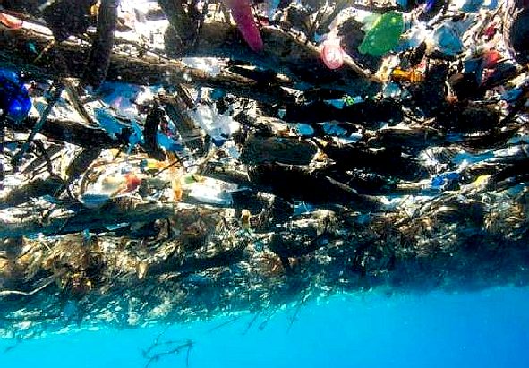
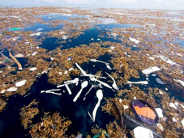
PLASTIC TIDE - These amazing pictures of a giant plastic tide were taken by Caroline Power. Please note how plastic and sargassum intertwine, creating a separation problem.
CARIBBEAN ISLANDS UNDER THREAT A-Z
Aruba (Netherlands) Cayman Islands (UK) Curaçao (Netherlands) Dominican Republic (Hispaniola) Guadeloupe
(France) Saint
Vincent and the Grenadines Turks
and Caicos Islands
LINKS & REFERENCE
http://www.
This website is provided on a free basis as a public information service. copyright © Cleaner Oceans Foundation Ltd (COFL) (Company No: 4674774) August 2022. Solar Studios, BN271RF, United Kingdom. COFL is a charity without share capital. The names Amphimax™ RiverVax™ and SeaVax™ are trademarks.
|