|
THE
CASPIAN SEA
HOME -
A-Z INDEX
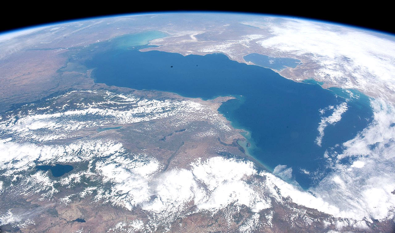
The Caspian Sea is the world's largest inland body of
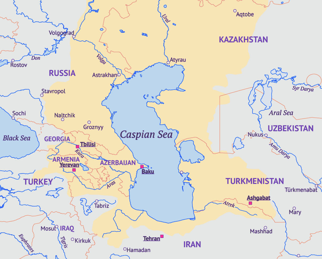
water, often described as the world's largest lake or a full-fledged sea. An endorheic basin, it lies between Europe and Asia: east of the Caucasus, west of the broad steppe of Central Asia, south of the fertile plains of Southern Russia in Eastern Europe, and north of the mountainous Iranian Plateau. It covers a surface area of 371,000 km2 (143,000 sq mi) (excluding the highly saline lagoon of Garabogazköl to its east), an area approximately equal to that of Japan, with a volume of 78,200 km3 (19,000 cu mi). It has a salinity of approximately 1.2% (12 g/L), about a third of the salinity of average seawater. It is bounded by Kazakhstan to the northeast, Russia to the northwest, Azerbaijan to the southwest, Iran to the south, and Turkmenistan to the southeast.
The sea stretches 1,200 km (750 mi) from north to south, with an average width of 320 km (200 mi). Its gross coverage is 386,400 km2 (149,200 sq mi) and the surface is about 27 m (89 ft) below sea level. Its main freshwater inflow, Europe's longest river, the Volga, enters at the shallow north end. Two deep basins form its central and southern zones. These lead to horizontal differences in temperature, salinity, and ecology. The seabed in the south reaches 1,023 m (3,356 ft) below sea level, which is the second-lowest natural non-oceanic depression on Earth after Lake Baikal (−1,180 m or −3,870 ft).
Written accounts from the ancient inhabitants of its coast perceived the Caspian Sea as an ocean, probably because of its salinity and large size. With a surface area of 371,000 square kilometres (143,000 sq mi), the Caspian Sea is nearly five times as big as Lake Superior (82,000 square kilometres (32,000 sq mi)). The Caspian Sea is home to a wide range of species and is famous for its caviar and oil industries. Pollution from the oil industry and dams on rivers that drain into it have harmed its ecology. It is predicted that during the 21st century, the depth of the sea will decrease by 9–18 m (30–60 ft) due to global warming and the process of desertification, causing an ecocide.
OCEAN
AWARENESS CAMPAIGN - As
part of the Cleaner Ocean Foundation's ocean
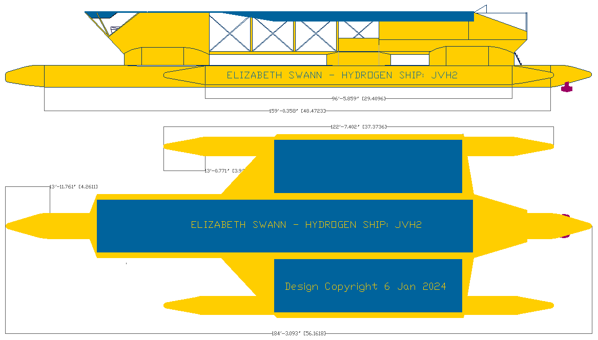
literacy campaigns, the not for profit is developing the Elizabeth
Swann, a solar and hydrogen powered craft, to demonstrate
clean blue water and river cruises are technologically closer
than you might think. Hence, Mediterranean, Red Sea, and Nile
river cruises. It would be possible to reach the Caspian Sea
with the Elizabeth Swann via the River Volga. If all ships
were powered by renewable energy, the Caspian Sea might not be
subjected to desertification and subsequent ecocide.
FLORA
The rising level of the Caspian Sea between 1995 and 1996 reduced the number of habitats for rare species of aquatic vegetation. This has been attributed to a general lack of seeding material in newly formed coastal lagoons and water bodies.
Many rare and endemic plant species of Russia are associated with the tidal areas of the Volga delta and riparian forests of the Samur River delta. The shoreline is also a unique refuge for plants adapted to the loose sands of the Central Asian Deserts. The principal limiting factors to successful establishment of plant species are hydrological imbalances within the surrounding deltas, water pollution, and various land reclamation activities. The water level change within the Caspian Sea is an indirect reason for which plants may not get established.
These affect aquatic plants of the Volga Delta, such as Aldrovanda vesiculosa and the native Nelumbo caspica. About 11 plant species are found in the Samur River delta, including the unique liana forests that date back to the Tertiary period.
Since 2019 UNESCO has admitted the lush Hyrcanian forests of Mazandaran, Iran as
World Heritage Site under category (ix).
FAUNA
The Caspian turtle (Mauremys caspica), although found in neighboring areas, is a wholly freshwater species. The zebra mussel is native to the Caspian and Black Sea basins, but has become an invasive species elsewhere, when introduced. The area has given its name to several species, including the Caspian gull and the Caspian tern. The Caspian seal (Pusa caspica) is the only aquatic mammal endemic to the Caspian Sea, being one of very few seal species that live in inland waters, but it is different from those inhabiting freshwaters due to the hydrological environment of the sea. A century ago the Caspian was home to more than one million seals. Today, fewer than 10% remain.
Archeological studies of Gobustan Rock Art have identified what may be dolphins and porpoises, likely present in the Caspian Sea at least until the Quaternary or much more recent periods such as the last glacial period or antiquity. Although the rock art on Kichikdash Mountain is assumed to be of a dolphin it might instead represent the famous beluga sturgeon due to its size (430 cm in length), but fossil records suggest certain ancestors of modern dolphins and whales, such as Macrokentriodon morani (bottlenose dolphins) and Balaenoptera sibbaldina
(blue
whales) were presumably larger than their present descendants. From the same artworks, auks, like Brunnich's Guillemot could also have been in the sea as well, and these petroglyphs suggest marine inflow between the current Caspian Sea and the
Arctic Ocean or North Sea, or the Black Sea. This is supported by the existences of current endemic, oceanic species such as lagoon cockles which was genetically identified to originate in Caspian/Black Seas regions.
The sea's basin (including associated waters such as rivers) has 160 native species and subspecies of fish in more than 60 genera. About 62% of the species and subspecies are endemic, as are 4–6 genera (depending on taxonomic treatment). The lake proper has 115 natives, including 73 endemics (63.5%). Among the more than 50 genera in the lake proper, 3–4 are endemic: Anatirostrum, Caspiomyzon, Chasar (often included in Ponticola) and Hyrcanogobius. By far the most numerous families in the lake proper are gobies (35 species and subspecies), cyprinids (32) and clupeids (22). Two particularly rich genera are Alosa with 18 endemic species/subspecies and Benthophilus with 16 endemic species. Other examples of endemics are four species of Clupeonella, Gobio volgensis, two Rutilus, three Sabanejewia, Stenodus leucichthys, two Salmo, two Mesogobius and three Neogobius. Most non-endemic natives are either shared with the Black Sea basin or widespread Palearctic species such as crucian carp, Prussian carp, common carp, common bream, common bleak, asp, white bream, sunbleak, common dace, common roach, common rudd, European chub, sichel, tench, European weatherfish, wels catfish, northern pike, burbot, European perch and zander. Almost 30 non-indigenous, introduced fish species have been reported from the Caspian Sea, but only a few have become established.
Six sturgeon species, the Russian, bastard, Persian, sterlet, starry and beluga, are native to the Caspian Sea. The last of these is arguably the largest freshwater fish in the world. The sturgeon yield roe (eggs) that are processed into caviar. Overfishing has depleted a number of the historic fisheries. In recent years,
overfishing has threatened the sturgeon population to the point that environmentalists advocate banning sturgeon
fishing completely until the population recovers. The high price of sturgeon caviar – more than 1,500 Azerbaijani manats (US$880 as of April 2019) per kilo – allows fishermen to afford bribes to ensure the authorities look the other way, making regulations in many locations ineffective. Caviar harvesting further endangers the fish stocks, since it targets reproductive females.
Reptiles native to the region include the spur-thighed tortoise (Testudo graeca buxtoni) and Horsfield's tortoise.
- The Asiatic cheetah used to occur in the Trans-Caucasus and Central Asia, but is today restricted to Iran.
- The Asiatic lion used to occur in the Trans-Caucasus, Iran, and possibly the southern part of Turkestan.
- The Caspian tiger used to occur in northern Iran, the Caucasus and Central Asia.
- The endangered Persian leopard is found in Iran, the Caucasus and Central Asia.
ECONOMY
Countries in the Caspian region, particularly Azerbaijan, Kazakhstan and Turkmenistan, have high-value natural-resource-based economies, where the oil and gas compose more than 10 percent of their GDP and 40 percent of their exports. All the Caspian region economies are highly dependent on this type of mineral wealth. The world energy markets were influenced by Azerbaijan and Kazakhstan, as they became strategically crucial in this sphere, thus attracting the largest share of foreign direct investment (FDI).
All of the countries are rich in solar energy and harnessing potential, with the highest rainfall much less than the mountains of central Europe in the mountains of the west, which are also rich in hydroelectricity sources.
Iran has high fossil fuel energy potential. It has reserves of 137.5 billion barrels of crude oil, the fourth largest in the world, producing around four million barrels a day. Iran has an estimated 988.4 trillion cubic feet of natural gas, around 16 percent of world reserves, thus key to current paradigms in global energy security.
Russia's economy ranks as the twelfth largest by nominal GDP and sixth largest by purchasing power parity in 2015. Russia's extensive mineral and energy resources are the largest such reserves in the world, making it the second leading producer of oil and natural gas globally.
Caspian littoral states join efforts to develop infrastructure, tourism and trade in the region. The first Caspian Economic Forum was convened on August 12, 2019, in Turkmenistan and brought together representatives of Kazakhstan, Russia, Azerbaijan, Iran and that state. It hosted several meetings of their ministers of economy and transport.
The Caspian countries develop robust cooperation in the tech and digital field as part of the Caspian Digital Hub. The project helps expand data transmission capabilities in Kazakhstan as well as data transit capabilities between Asia and Europe. The project generated interest from investors from all over the world, including the UK.
OIL AND GAS
The area is rich in fossil
fuels. Oil wells were being dug in the region as early as the 10th century to reach oil "for use in everyday life, both for medicinal purposes and for heating and lighting in homes". By the 16th century, Europeans were aware of the rich oil and gas deposits locally. English traders Thomas Bannister and Jeffrey Duckett described the area around Baku as "a strange thing to behold, for there issueth out of the ground a marvelous quantity of oil, which serveth all the country to burn in their houses. This oil is black and is called nefte. There is also by the town of Baku, another kind of oil which is white and very precious [i.e.,
petroleum]."
Today, oil and gas platforms abound along the edges of the sea.
The Caspian Sea region presently is a significant, but not major, supplier of crude oil to world markets, based upon estimates by BP Amoco and the U.S. Energy Information Administration, U.S. Department of Energy. The region output about
1.4 - 1.5 million barrels per day plus natural gas liquids in 2001, 1.9% of total world output. More than a dozen countries output more than this top figure. Caspian region production has been higher, but waned during and after the collapse of the Soviet Union. Kazakhstan accounts for 55% and Azerbaijan for about 20% of the states' oil output.
The world's first offshore wells and machine-drilled wells were made in Bibi-Heybat Bay, near Baku, Azerbaijan. In 1873, exploration and development of oil began in some of the largest fields known to exist in the world at that time on the Absheron Peninsula near the villages of Balakhanli, Sabunchi, Ramana, and Bibi Heybat. Total recoverable reserves were more than 500 million tons. By 1900, Baku had more than 3,000 oil wells, 2,000 of which were producing at industrial levels. By the end of the 19th century, Baku became known as the "black gold capital", and many skilled workers and specialists flocked to the city.
By the beginning of the 20th century, Baku was the center of the international oil industry. In 1920, when the Bolsheviks captured Azerbaijan, all private property, including oil wells and factories, was confiscated. Rapidly the republic's oil industry came under the control of the Soviet Union. By 1941, Azerbaijan was producing a record 23.5 million tons of oil per year – its Baku region output was nearly 72 percent of the Soviet Union's oil.
In 1994, the "Contract of the Century" was signed, heralding extra-regional development of the Baku oil fields. The large Baku–Tbilisi–Ceyhan pipeline conveys Azeri oil to the Turkish Mediterranean port of Ceyhan and opened in 2006.
The Vladimir Filanovsky [ru] oil field in the Russian section of the body of water was discovered in 2005. It is reportedly the largest found in 25 years. It was announced in October 2016 that Lukoil would start production from it.
TRANSPORT
Baku has the main moorings of all large vessels, such as oil tankers, in Azerbaijan. It is the largest port of the Caspian Sea. The port (and tankers) have access to the oceans along the Caspian Sea–Volga–Don Canal, and the Don–Sea of Azov. A northern alternate is the Volga–Baltic (a sea which has a connection to the North Sea of the Atlantic, as the White Sea does via the White Sea-Baltic canal). Baku Sea Trade Port and Caspian Shipping Company CJSC, have a big role in the sea transportation of Azerbaijan. The Caspian Sea Shipping Company CJSC has two fleets plus shipyards. Its transport fleet has 51 vessels: 20 tankers, 13 ferries, 15 universal dry cargo vessels, 2 Ro-Ro vessels, as well as 1 technical vessel and 1 floating workshop. Its specialized fleet has 210 vessels: 20 cranes, 25 towing and supplying vehicles, 26 passenger, two pipe-laying, six fire-fighting, seven engineering-geological, two diving and 88 auxiliary vessels.
The Caspian Sea Shipping Company of Azerbaijan, which acts as a liaison in the Transport Corridor Europe-Caucasus-Asia (TRACECA), simultaneously with the transportation of cargo and passengers in the Trans-Caspian direction, also performs work to fully ensure the processes of oil and gas production at sea. In the 19th century, the sharp increase in oil production in Baku gave a huge impetus to the development of shipping in the Caspian Sea, and as a result, there was a need to create fundamentally new floating facilities for the transportation of oil and oil products.
Although the Caspian Sea is endorheic, its main tributary, the Volga, is connected by important shipping canals with the Don River (and thus the Black Sea) and with the Baltic Sea, with branch canals to Northern Dvina and to the White Sea.
Another Caspian tributary, the Kuma River, is connected by an irrigation canal with the Don basin as well.
Scheduled ferry services (including train ferries) across the sea chiefly are between:
- Türkmenbaşy in Turkmenistan, (formerly Krasnovodsk) and Baku.
- Aktau, Kazakhstan and Baku.
- Cities in Iran and Russia (chiefly for cargo.)
POLITICS
Many of the islands along the Azerbaijani coast retain great geopolitical and economic importance for demarcation-line oil fields relying on their national status. Bulla Island, Pirallahı Island, and Nargin, which is still used as a former Soviet base and is the largest island in the Baku bay, hold oil reserves.
The collapse of the Soviet Union allowed the market opening of the region. This led to intense investment and development by international oil companies. In 1998, Dick Cheney commented that "I can't think of a time when we've had a region emerge as suddenly to become as strategically significant as the Caspian."
A key problem to further local development is arriving at precise, agreed demarcation lines among the five littoral states. The current disputes along Azerbaijan's maritime borders with Turkmenistan and Iran could impinge future development.
Much controversy currently exists over the proposed Trans-Caspian oil and gas pipelines. These projects would allow Western markets easier access to Kazakh oil and, potentially, Uzbek and Turkmen gas as well. Russia officially opposes the project on environmental grounds. However, analysts note that the pipelines would bypass Russia completely, thereby denying the country valuable transit fees, as well as destroying its current monopoly on westward-bound hydrocarbon exports from the region. Recently, both Kazakhstan and Turkmenistan have expressed their support for the Trans-Caspian Pipeline.
Leaked U.S. diplomatic cables revealed that BP covered up a gas leak and blowout incident in September 2008 at an operating gas field in the Azeri-Chirag-Guneshi area of the Azerbaijan Caspian Sea.
CANALS
As an endorheic basin, the Caspian Sea basin has no natural connection with the ocean. Since the medieval period, traders reached the Caspian via a number of portages that connected the Volga and its tributaries with the Don River (which flows into the Sea of Azov) and various rivers that flow into the Baltic Sea. Primitive canals connecting the Volga Basin with the Baltic were constructed as early as the early 18th century. Since then, a number of canal projects have been completed.
The two modern canal systems that connect the Volga Basin, and hence the Caspian Sea, with the ocean are the Volga–Baltic Waterway and the Volga–Don Canal.
The proposed Pechora–Kama Canal was a project that was widely discussed between the 1930s and 1980s. Shipping was a secondary consideration. Its main goal was to redirect some of the water of the Pechora River (which flows into the Arctic Ocean) via the Kama River into the Volga. The goals were both irrigation and the stabilization of the water level in the Caspian, which was thought to be falling dangerously fast at the time. During 1971, some peaceful nuclear construction experiments were carried out in the region by the U.S.S.R.
In June 2007, in order to boost his oil-rich country's access to markets, Kazakhstan's President Nursultan Nazarbayev proposed a 700 km (435 mi) link between the Caspian Sea and the Black Sea. It is hoped that the "Eurasia Canal" (Manych Ship Canal) would transform landlocked Kazakhstan and other Central Asian countries into maritime states, enabling them to significantly increase trade volume. Although the canal would traverse Russian territory, it would benefit Kazakhstan through its Caspian Sea ports. The most likely route for the canal, the officials at the Committee on Water Resources at Kazakhstan's Agriculture Ministry say, would follow the Kuma–Manych Depression, where currently a chain of rivers and lakes is already connected by an irrigation canal (the Kuma–Manych Canal). Upgrading the Volga–Don Canal would be another option.
TERRITORIAL STATUS
Five states are located along about 4,800 km (3,000 mi) of Caspian coastline. The length of the coastline of these countries:[80]
Kazakhstan - 1,422 km (884 mi)
Turkmenistan - 1,035 km (643 mi)
Azerbaijan - 813 km (505 mi)
Russia - 747 km (464 mi)
Iran - 728 km (452 mi)

GEOGRAPHY
The coastlines of the Caspian are shared by Azerbaijan, Iran, Kazakhstan, Russia, and Turkmenistan. The Caspian is divided into three distinct physical regions: the Northern, Middle, and Southern Caspian. The Northern–Middle boundary is the Mangyshlak Threshold, which runs through Chechen Island and Cape Tiub-Karagan. The Middle–Southern boundary is the Apsheron Threshold, a sill of tectonic origin between the Eurasian continent and an oceanic remnant, that runs through Zhiloi Island and Cape Kuuli. The Garabogazköl Bay is the saline eastern inlet of the Caspian, which is part of Turkmenistan and at times has been a lake in its own right due to the isthmus that cuts it off from the Caspian.
Differences between the three regions are dramatic. The Northern Caspian only includes the Caspian shelf, and is very shallow; it accounts for less than 1% of the total water volume with an average depth of only 5–6 m (16–20 ft). The sea noticeably drops off towards the Middle Caspian, where the average depth is 190 m (620 ft). The Southern Caspian is the deepest, with oceanic depths of over 1,000 m (3,300 ft), greatly exceeding the depth of other regional seas, such as the Persian Gulf. The Middle and Southern Caspian account for 33% and 66% of the total water volume, respectively. The northern portion of the Caspian Sea typically freezes in the winter, and in the coldest winters ice forms in the south as well.
Over 130 rivers provide inflow to the Caspian, the Volga River being the largest. A second affluent, the Ural River, flows in from the north, and the Kura River from the west. In the past, the Amu Darya (Oxus) of Central Asia in the east often changed course to empty into the Caspian through a now-desiccated riverbed called the Uzboy River, as did the Syr Darya farther north. The Caspian has several small islands, primarily located in the north with a collective land area of roughly 2,000 km2 (770 sq mi). Adjacent to the North Caspian is the Caspian Depression, a low-lying region 27 m (89 ft) below sea level. The Central Asian steppes stretch across the northeast coast, while the Caucasus mountains hug the western shore. The biomes to both the north and east are characterized by cold, continental deserts. Conversely, the climate to the southwest and south are generally warm with uneven elevation due to a mix of highlands and mountain ranges; the drastic changes in climate alongside the Caspian have led to a great deal of biodiversity in the region.
The Caspian Sea has numerous islands near the coasts, but none in the deeper parts of the sea. Ogurja Ada is the largest island. The island is 37 km (23 mi) long, with gazelles roaming freely on it. In the North Caspian, the majority of the islands are small and uninhabited, like the Tyuleniy Archipelago, an Important Bird Area (IBA).
CLIMATE
The climate of the Caspian Sea is variable, with the cold desert climate (BWk), cold semi-arid climate (BSk), and humid continental climate (Dsa, Dfa) being present in the northern portions of the Caspian Sea, while the Mediterranean climate (Csa) and humid subtropical climate (Cfa) are present in the southern portions of the Caspian Sea.
HYDROLOGY
The Caspian has characteristics common to both seas and lakes. It is often listed as the world's largest lake, although it is not freshwater: the 1.2% salinity classes it with brackish water bodies.
It contains about 3.5 times as much water, by volume, as all five of North America's Great Lakes combined. The Volga River (about 80% of the inflow) and the Ural River discharge into the Caspian Sea, but it has no natural outflow other than by evaporation. Thus the Caspian ecosystem is a closed basin, with its own sea level history that is independent of the eustatic level of the world's oceans.
The sea level of the Caspian has fallen and risen, often rapidly, many times over the centuries. Some Russian
historians claim that a medieval rising of the Caspian, perhaps caused by the Amu Darya changing its inflow to the Caspian from the 13th century to the 16th century, caused the coastal towns of Khazaria, such as Atil, to flood. In 2004, the water level was 28 m (92 ft) below sea level.
Over the centuries, Caspian Sea levels have changed in synchrony with the estimated discharge of the Volga, which in turn depends on rainfall levels in its vast catchment basin. Precipitation is related to variations in the amount of North Atlantic depressions that reach the interior, and they in turn are affected by cycles of the North Atlantic oscillation. Thus levels in the Caspian Sea relate to atmospheric conditions in the North Atlantic, thousands of kilometres to the northwest.
The last short-term sea-level cycle started with a sea-level fall of 3 m (10 ft) from 1929 to 1977, followed by a rise of 3 m (10 ft) from 1977 until 1995. Since then smaller oscillations have taken place.
A study by the Azerbaijan Academy of Sciences estimated that the level of the sea was dropping by more than six centimetres per year due to increased evaporation due to rising temperatures caused by
climate change.
ENVIRONMENTAL DEGRADATION
The Volga River, the longest river in Europe, drains 20% of the European land area and is the source of 80% of the Caspian's inflow. Heavy development in its lower reaches has caused numerous unregulated releases of chemical and biological pollutants. The UN Environment Programme warns that the Caspian "suffers from an enormous burden of pollution from oil extraction and refining, offshore oil fields, radioactive wastes from nuclear power plants and huge volumes of untreated sewage and industrial waste introduced mainly by the Volga River".
The magnitude of fossil fuel extraction and transport activity in the Caspian also poses a risk to the environment. The island of Vulf off Baku, for example, has suffered ecological damage as a result of the petrochemical industry; this has significantly decreased the number of species of marine birds in the area. Existing and planned oil and gas pipelines under the sea further increase the potential threat to the environment.
The high concentration of mud volcanoes under the Caspian Sea were thought to be the cause of a fire that broke out 75 kilometers from Baku on July 5, 2021. The State oil company of Azerbaijan
SOCAR said preliminary information indicated it was a mud volcano which spewed both mud and flammable gas.
It is calculated that during the 21st century, the water level of the Caspian Sea will decrease by 9–18 m (30–60 ft) due to the acceleration of evaporation due to global warming and the process of desertification, causing an ecocide.
On October 23, 2021, Kazakhstan President Kassym-Jomart Tokayev signed the Protocol for the Protection of the Caspian Sea against Pollution from Land-based Sources in order to ensure better protection for the biodiversity of the Caspian Sea.

LINKS
& REFERENCE
https://
AEGEAN
- ACIDIFICATION
- ADRIATIC
- AMBRACIAN
GULF
- ARCTIC
- ATLANTIC
- BALTIC
- BAY
BENGAL - BAY
BISCAY - BERING
- BLACK
- CARIBBEAN
- CASPIAN
- CORAL
- EAST
CHINA SEA
ENGLISH
CH - GOC
- GUANABARA
- GULF
GUINEA - GULF
MEXICO - INDIAN
-
IRC - IONIAN - IRISH
- MEDITERRANEAN
- NORTH
SEA - PACIFIC
- PERSIAN
GULF - SEA
JAPAN
STH
CHINA - PLASTIC
- PLANKTON
- PLASTIC
OCEANS - RED
- SARGASSO
- SEA
LEVEL RISE - SOUTHERN - TYRRHENIAN
- UNCLOS
- UNEP
- WOC
- WWF
This
website is provided on a free basis as a public information
service. copyright © Cleaner
Oceans Foundation Ltd (COFL) (Company No: 4674774)
2025 Solar
Studios, BN271RF, United Kingdom.
COFL
is a charity without share capital. The names Amphimax™
and SeaVax™
are trademarks.
|