|
OCEANS & SEAS OF THE WORLD
Please use our A-Z to navigate this site or return HOME
The world ocean is the principal component of Earth's hydrosphere, it is integral to all known life, forms part of the carbon cycle, and influences
climate and weather patterns. The world ocean is the habitat of 230,000 known species, but because much of it is unexplored, the number of species that exist is much larger, possibly over two million. The origin of Earth's oceans remains unknown; oceans are thought to have formed in the Hadean period and may have been the impetus for the emergence of life.
OCEANIC ZONES
The pelagic part of the aphotic zone can be further divided into vertical regions according to temperature. The mesopelagic is the uppermost region. Its lowermost boundary is at a thermocline of 12 °C (54 °F), which, in the tropics generally lies at 700–1,000 meters (2,300–3,300 ft). Next is the bathypelagic lying between 10 and 4 °C (50 and 39 °F), typically between 700–1,000 meters (2,300–3,300 ft) and 2,000 - 4,000 meters (6,600–13,100 ft), lying along the top of the abyssal plain is the abyssopelagic, whose lower boundary lies at about 6,000 meters (20,000 ft). The last zone includes the deep oceanic trench, and is known as the hadalpelagic. This lies between 6,000–11,000 meters (20,000–36,000 ft) and is the deepest oceanic zone.
The benthic zones are aphotic and correspond to the three deepest zones of the deep-sea. The bathyal zone covers the continental slope down to about 4,000 meters (13,000 ft). The abyssal zone covers the abyssal plains between 4,000 and 6,000 m. Lastly, the hadal zone corresponds to the hadalpelagic zone, which is found in oceanic trenches.
The pelagic zone can be further subdivided into two subregions: the neritic zone and the oceanic zone. The neritic zone encompasses the water mass directly above the continental shelves whereas the oceanic zone includes all the completely open water.
In contrast, the littoral zone covers the region between low and high tide and represents the transitional area between marine and terrestrial conditions. It is also known as the intertidal zone because it is the area where tide level affects the conditions of the region.
The ocean can be divided into three density zones: the surface zone, the pycnocline, and the deep zone. The surface zone, also called the mixed layer, refers to the uppermost density zone of the ocean. Temperature and salinity are relatively constant with depth in this zone due to currents and wave action. The surface zone contains ocean water that is in contact with the atmosphere and within the photic zone. The surface zone has the ocean's least dense water and represents approximately 2% of the total volume of ocean water. The surface zone usually ranges between depths of 500 feet (150 m) to 3,300 feet (1,000 m) below ocean surface, but this can vary a great deal. In some cases, the surface zone can be entirely non-existent. The surface zone is typically thicker in the tropics than in regions of higher latitude. The transition to colder, denser water is more abrupt in the tropics than in regions of higher latitudes. The pycnocline refers to a zone wherein density substantially increases with depth due primarily to decreases in temperature. The pycnocline effectively separates the lower-density surface zone above from the higher-density deep zone below. The pycnocline represents approximately 18% of the total volume of ocean water. The deep zone refers to the lowermost density zone of the ocean. The deep zone usually begins at depths below 3,300 feet (1,000 m) in mid-latitudes. The deep zone undergoes negligible changes in water density with depth. The deep zone represents approximately 80% of the total volume of ocean water. The deep zone contains relatively colder and stable water.
If a zone undergoes dramatic changes in temperature with depth, it contains a thermocline. The tropical thermocline is typically deeper than the thermocline at higher latitudes. Polar waters, which receive relatively little solar energy, are not stratified by temperature and generally lack a thermocline because surface water at polar latitudes are nearly as cold as water at greater depths. Below the thermocline, water is very cold, ranging from −1 °C to 3 °C. Because this deep and cold layer contains the bulk of ocean water, the average temperature of the world ocean is 3.9 °C.[citation needed] If a zone undergoes dramatic changes in salinity with depth, it contains a halocline. If a zone undergoes a strong, vertical chemistry gradient with depth, it contains a chemocline. The halocline often coincides with the thermocline, and the combination produces a pronounced pycnocline.
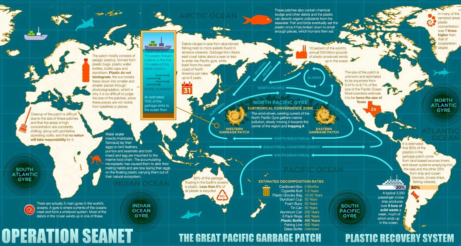
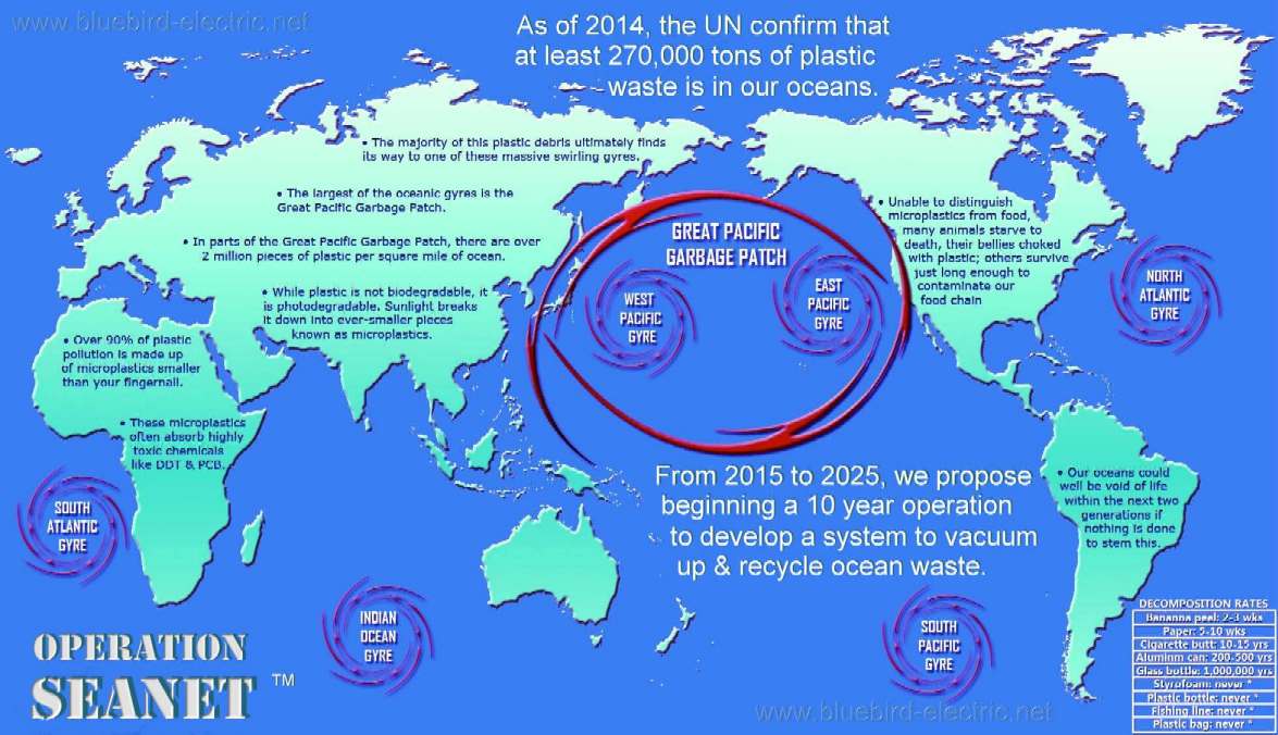
There are 5 swirling ocean garbage patches called gyres. The largest gyre is the Great Pacific Garbage Patch, located between Hawaii and California, held to be about the size of France or Texas at the moment.
A
- Z LIST
OF SEAS & OCEANS, BAYS & GULFS ADRIATIC
SEA Ambracian
Gulf of Arta Bismarck Sea Cape
Of Good Hope ENGLISH
CHANNEL GUANABARA BAY GULF
OF GUINEA - Sargassum
evaluation Gulf
of Thailand Horn
of Africa - Somali Peninsula INDIAN
OCEAN - Sargassum
evaluation PERSIAN
GULF
LINKS & REFERENCE
https://en.wikipedia.org/wiki/Ocean#Oceanic_divisions http://www.worldatlas.com/aatlas/infopage/oceans.htm
FISHING NETS - MICROBEADS - MICRO PLASTICS - OCEAN GYRES - OCEAN WASTE - PLASTIC - POPS
This website is provided on a free basis as a public information service. copyright © Cleaner Oceans Foundation Ltd (COFL) (Company No: 4674774) 2025. Solar Studios, BN271RF, United Kingdom. COFL is a charity without share capital. The names Amphimax™ SeaNet™ and SeaVax™ are trademarks.
|